
2801 Jay Road housing proposal faces unresolved path, access questions
The 82-home proposal still needs decisions on a multi-use path, pedestrian connections, bus access and a city-county right-of-way conflict as site review continues.
Published at
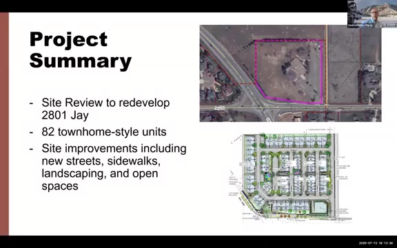
An 82-home redevelopment at 2801 Jay Road faces unresolved questions about a multi-use path, pedestrian and bicycle connections, bus access and a disputed right-of-way arrangement, according to the July 13 Transportation Advisory Board discussion.
The 4.6-acre proposal includes 49 market-rate attached homes and 33 permanently affordable attached homes for middle-income buyers. The applicant told the board that about 72% of the affordable units would have three bedrooms and estimated the project would add 34 vehicle trips during the peak hour.
The advisory board did not approve or deny the project. Staff said it generally met transportation and comprehensive-plan goals but needed revisions, and the board’s feedback will go to the Planning Board as part of the site-review process, staff told the board. City project-history records identify the application as site-review case LUR2025-00044. No final site-review approval was identified in the records reviewed for this report.
Path construction or deferred funds
The main unresolved transportation question is whether the project should build a planned north-south multi-use path now or provide money for construction later, when it could connect to future development or a planned city park in Area 3.
The applicant argued that building the path immediately could leave it ending at the property line without a near-term connection. City engineering staff preferred construction but said the annexation agreement allows a cash alternative. Staff said the city would hold deferred funds until construction becomes feasible and warned that a path costing about $25,000 today could cost substantially more in 10 years.
The record does not identify the specific account, how the money would be adjusted for inflation or a deadline for spending it. It also does not establish whether the final site-review decision will require construction now or accept the cash option.
Board members sought a more connected internal layout, including wider or more direct paths, possible gates from rear-facing homes and connections to schools, transit and the site perimeter. The applicant said most paths would be 5 feet wide, with one 4-foot connection, and said it was willing to widen paths where feasible. Utility constraints and fee-simple residential lots were cited as limits on some routes.
The plan also includes public streets, sidewalks, trails, open space, bicycle storage, electric-vehicle chargers and 39 on-street parking spaces. A north-side bus stop is planned with a new pad, bus area, bench and bike racks. A fully accessible south-side stop remains unresolved because of right-of-way constraints and will require coordination among the applicant, city staff, RTD and Boulder County.
City, county still must resolve access conflict
A separate issue involves a proposed city right of way near an existing private access drive on Boulder County property. The drive serves about three properties, and county officials raised concerns about the proximity of the two access points.
City engineering staff said the arrangement appears workable because use of the private drive is limited, but said the city and applicant were still working with Boulder County and could not complete the arrangement without the county’s approval. The meeting record does not show a final design, county signoff or formal resolution of the conflict.
The applicant said site review could continue through the end of 2026, followed by technical-document review and infrastructure redesign in 2027. Construction could begin near the end of 2027 if those steps and later approvals are completed. The 34-trip projection is the applicant’s estimate; the available meeting record does not include an independent staff or county analysis of its assumptions or intersection-level effects.