
Boulder staff propose 2030 wildfire goals for 12 western areas
The plan would assess 55% of homes and harden 20% in the priority areas, while organizing 137 projects into 25 programs.
Published at
Boulder staff have completed a wildfire-resilience framework proposing that, by the end of 2030, detailed assessments reach 55% of homes in 12 western areas and 20% be hardened to a specified wildfire-preparedness standard.
The framework in the packet for City Council’s Oct. 22 study session groups 137 projects into 25 programs, including 10 top priorities. Staff are seeking council feedback, not a decision, and expect to finalize the framework after the discussion.
The assessment goal is for homes in the 12 areas to receive a detailed home assessment, which makes them eligible to apply for a city home-hardening grant. The hardening goal is for homes to meet the standard for the Wildfire Prepared Home Essential designation. These are proposed targets; an assessment does not guarantee a grant, and hardening does not guarantee the designation.
The framework also proposes evacuation-preparedness programming for 75% of homes in the areas by 2030. Other proposed measures include treating all city-owned acres in priority-area wildlands according to wildfire-risk prescriptions and undergrounding 20 miles of overhead utility lines. Staff propose tracking 14 measures from 2027 through 2030.
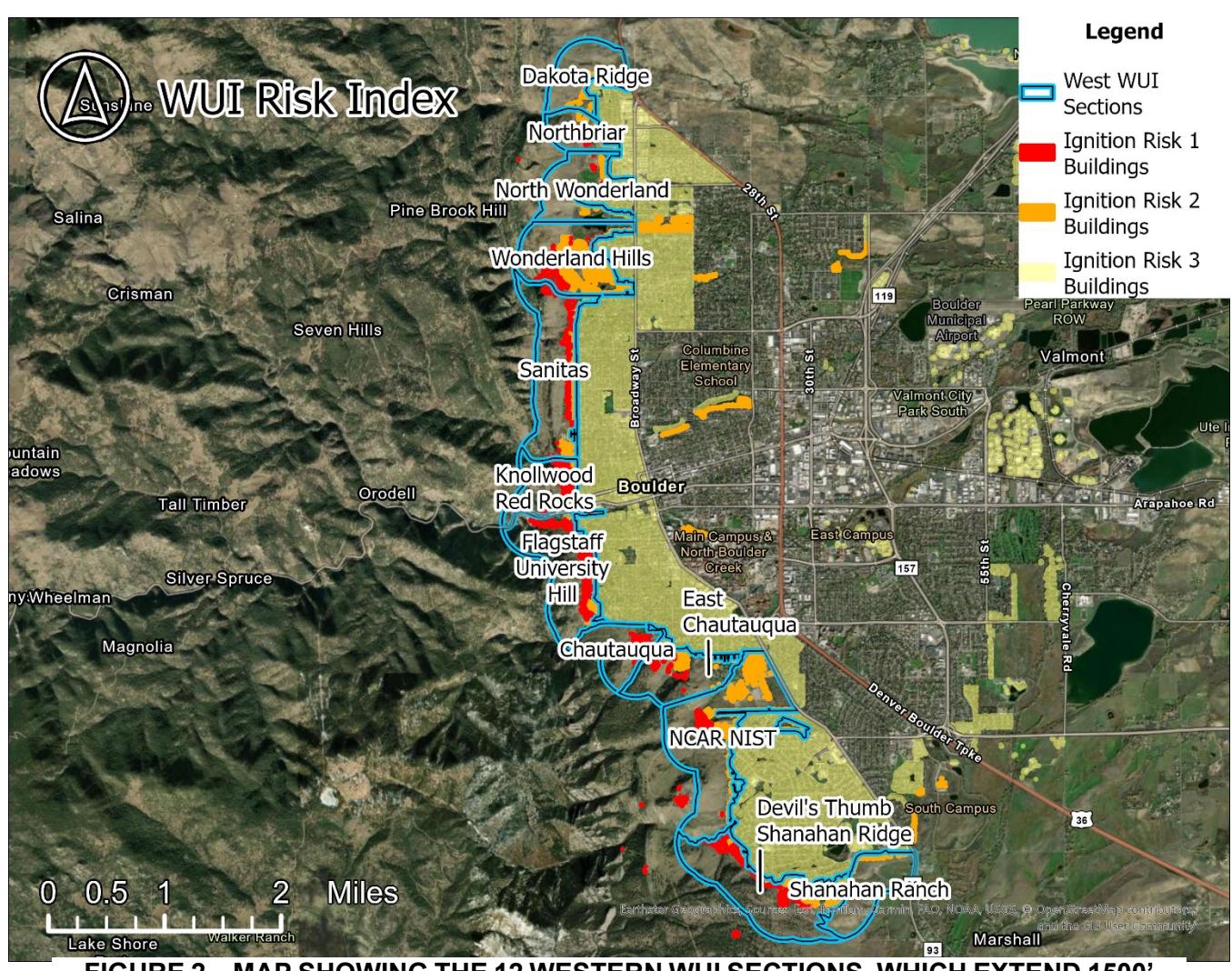
The 12 areas cover the western wildland-urban interface, not all of Boulder. Staff selected them based on denser, more continuous fuels, steeper terrain, higher modeled potential fire intensity and greater exposure of buildings. Boundaries generally extend about 1,500 feet west from residential buildings into wildland fuels; to the east, they include areas in the city’s two higher ignition-risk zones.
The risk index ranks the areas relative to one another; it does not assign an absolute level of wildfire risk. Its quantitative score weights the susceptibility of people and property to harm at 40%, potential fire intensity at 30% and exposure at 30%. Staff combine that score, which accounts for 70% of the final ranking, with a 30% qualitative assessment that includes evacuation access and firefighting challenges. The areas are grouped as “Highest,” “Very High” or “High” risk.
Staff propose annual reports on all 14 measures, using status labels such as on track, needing attention or off track, alongside summaries of progress, setbacks and resources. The report’s format and timing are undecided; staff identified spring as a possibility.
For 2027, staff identified potential enhancements totaling up to about $1.85 million: up to $500,000 for home and property risk reduction, $100,000 for emergency preparedness, $600,000 for fuels management and $650,000 for evacuation work. Potential support includes grants and up to $600,000 from the Open Space Fund. Staff also raised the possibility of shifting existing Climate Tax Fund spending. These are planning options, not an approved spending package. Staff plan to refine the work plan and funding shifts and return to council in spring 2027.
Those near-term options are separate from longer-term financing ideas. An Oct. 7 Environmental Advisory Board discussion explored a much larger investment scale and possibilities such as bonds and property-based financing. The Oct. 22 packet does not select a financing mechanism; staff plan to evaluate longer-term options during 2027 and bring them back to council.