
Louisville draft parks plans find land, recreation and staffing gaps
Draft 10-year parks and trail plans identify a 56-acre parkland shortfall, recreation-capacity constraints, trail-safety problems and staffing needs, but do not fund or approve projects.
Louisville’s draft 10-year parks and trail plans identify an estimated 56-acre parkland shortfall, recreation programs operating beyond available capacity, unsafe road crossings, missing trail links and environmentally damaging “social” trails. The plans are strategic frameworks, not approvals for construction, final trail alignments, project schedules or spending.
The draft PROS Guidebook and Long-Range Plan says Louisville has about 56 fewer acres of parkland than its benchmark standards call for. The estimate compares the city with national and peer-city measures; the document presents somewhat different per-capita figures in separate sections, so the figure is a planning estimate rather than a specific acquisition target.
The assessment also says demand exceeds physical capacity in aquatics, youth camps, fitness, senior programming, soccer, basketball and pickleball. It identifies pressure on the approximately 104,000-square-foot Recreation & Senior Center and Memory Square Pool, but does not provide program-by-program enrollment, waitlist or utilization figures.
The plans emphasize maintaining and upgrading existing facilities while also planning for future expansion. They call for condition-based deferred-maintenance priorities, preventive maintenance and lifecycle planning. Staffing needs identified in the drafts include park maintenance, aquatics and recreation programming, open-space education and stewardship, trail planning and coordination, and plan implementation. PROS reports 117 full-time-equivalent positions across its divisions but does not specify additional hires or a hiring timetable.
The drafts were scheduled for City Council discussion and direction Aug. 25. The supplied record does not establish what occurred at that discussion. Public comment is open through Sept. 13, and staff is targeting adoption of revised plans in fall 2026.
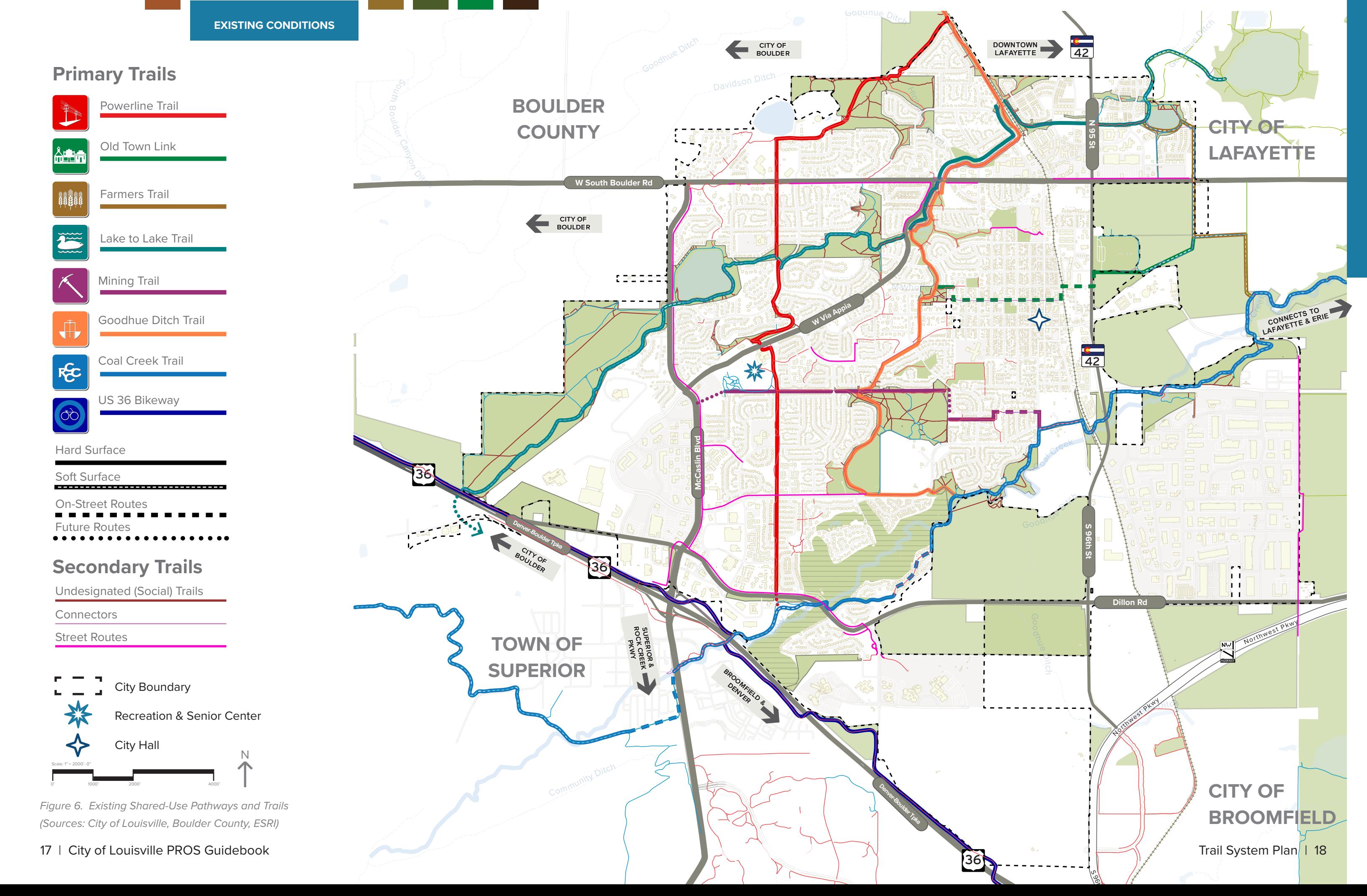
The plans cover Louisville’s 54.5-mile trail and pathway network and are intended to guide future work plans, budgets, the Capital Improvement Program and grant applications. Any projects or staffing changes would require later planning, funding and council action.
Trail crossings and connections
The draft Trail System Plan identifies safety and connectivity problems involving South Boulder Road, the BNSF railroad corridor, McCaslin Boulevard, West Cherry Street and 96th Street. It proposes regional and neighborhood connections, improved at-grade crossings, and new or upgraded underpasses and overpasses.
Named priorities include a Lake-to-Lake Trail underpass at U.S. 36; a connection along State Highway 43 north of Empire Road; links between Centennial Parkway and Davidson Mesa Trail, Via Appia Way and North Open Space, and Dillon Road and Coal Creek Trail; connections serving Louisville Middle School; and a route from Dillon Road south to Health Park Drive along 88th Street.
Advisory boards and the Trails Taskforce identified the Lake-to-Lake/U.S. 36 underpass and State Highway 43 connection as top regional priorities. Other leading crossing priorities included McCaslin Boulevard and West Cherry Street; West South Boulder Road at Coyote Run/Callahan Trail; and South Madison and South Polk avenues. The plan also recommends tools such as rectangular rapid-flashing beacons, traffic signals, improved visibility, drainage and lighting upgrades.
The plan does not establish final alignments, property rights, engineering designs or environmental approvals. It also does not provide a complete roadway-name crosswalk for every numbered map location.
Social trails
The Trail System Plan says the city inventoried about 11 miles of undesignated social trails in 2025. The paths form when visitors leave designated routes.
The proposal would close and revegetate social trails in the Open Space Preserve classification, subject to available resources. Other trails could be formalized, retained, temporarily closed, restored or monitored after case-by-case review. The plan says some social trails provide useful connections, while others damage vegetation, fragment habitat, disrupt wildlife movement, duplicate nearby routes or lack functional value.
Reviews would consider land classification, safety, wildlife habitat, trail saturation, erosion, invasive weeds, raptor nests, prairie-dog colonies, exposed roots, waterway impacts and hazardous road edges. New or upgraded formal trails would be evaluated for environmental sensitivity, connectivity, safety, accessibility, demand, feasibility, cost and maintenance impacts.
What could follow adoption
If adopted, the plans call for incremental implementation over more than a decade. One- to five-year actions could include wayfinding, signage, small gap closures, safety fixes, social-trail management and asset maintenance. Six- to 10-year work would emphasize broader regional connections and environmental stewardship. Ongoing work would include inspections, drainage and surface maintenance, vegetation management, erosion repair, visibility improvements and wildfire-risk reduction.
Potential funding sources include departmental budgets, the General Fund, voter-approved tax or bond initiatives, grants, partnerships, development contributions and philanthropic support. The plans do not identify awarded grants, secured partnerships, appropriations or a ranked project list.
The City Council report says the planning effort was funded with $300,000 for the long-range plan and $100,000 for the Trail System Plan. About $381,000 had been spent, leaving roughly $19,000 for consultant expenses and contingency; staff projected completion within the approved planning budget. The money paid for planning, not construction.
After adoption, PROS staff are expected to develop project details and costs through annual work plans, the Capital Improvement Program and the regular budget process. Timing would depend on funding, staffing, partnerships, technical and ecological review, additional public input and City Council action.